The Small Hikes
We went to Moab to explore the area and do some photography exploration over a week-long period. We arrived late on Sunday and left early on Friday which gave us 4 full days of hiking in this beautiful area. The weather cooperated most mornings and a few evenings for golden hour photography, but we got a variety of lighting from overcast, snowing, foggy, and full sun. In total, we hiked a little over 30 miles and over a mile in elevation on this trip. We came to the same conclusion that our favorite type of hiking is the type where we're alone or hiking with very few people so that we can enjoy nature to the fullest extent, as well as get a perfect photo with no one in it.
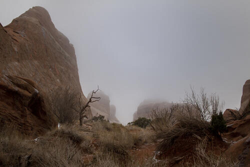
We did so many little hikes on our second full day in Moab. We started pretty early to try and get some earlyish morning photos, but the sun didn't come out. In fact, it started snowing as we were driving through the park and was snowing pretty hard as we got to the far end of the park in Devils Garden. But we were there and we're in Moab to hike, so we got out of the car and headed to Tunnel Arch and Pine Tree Arch, which were a short half mile to get to. The snow wasn't ideal, but the temperature wasn't too terrible and there was a slight breeze but overall made the hike pretty tolerable. Tunnel arch wasn't much to look at, and neither was Pine Tree Arch, but we did get some cool views of fog rolling through the area we were hiking.
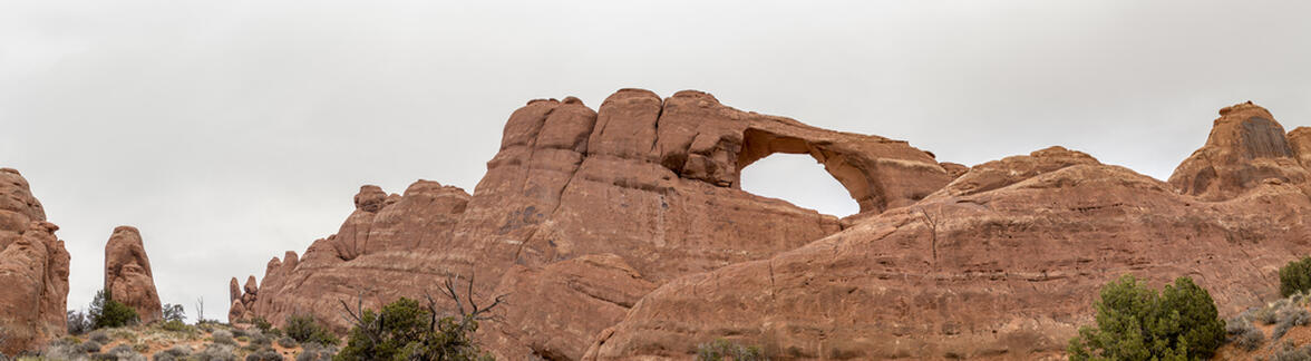
After leaving the Devil's Garden area, we stopped quickly at Skyline Arch, which is right off the side of the road and I wouldn't even consider a hike.
We moved onto Sandstone arch and Broken Arch after that which was the first real hike of the day at just over 2 miles long. It was still snowing when we started the hike, but only barely so. By the time we finished the hike, the sun was starting to peek out of the clouds. Sandstone arch is very aptly named since you hike through very thick sand that holds your feet down as you take each step. It wasn't very far, but the sand makes it much harder to walk. The hike to Broken Arch was different from the rest - we hiked through a prairie instead of between canyons or walls of sandstone. There were great views in every direction of the hike, including being able to see Broken Arch the entire time. When we got to Broken arch we wandered around to the backside and got a bunch of different views. Right before we left, the sun lit up the prairie behind Broken arch for us to get a well-lit photo.
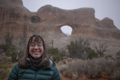
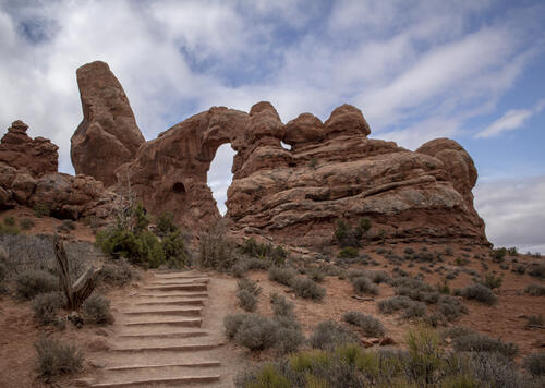
We then went back to the Windows area to try and get some better photos from a lighting perspective. With the sun being covered by clouds, we figured the photos would be different than the first day of this trip when we walked up to the Windows. We were also able to get some better photos of Turret Arch since the sun was still in the East and that's an arch that you shoot looking West. We took the "primitive" trail around the Windows which wasn't primitive at all, and wandered down to Double Arch which was just covered with people. There is no way we'd be able to get a photograph without people in Double Arch, but we weren't expecting too so the Arch met our expectations.
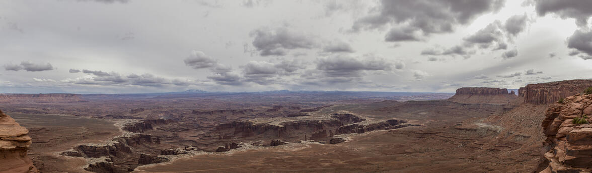
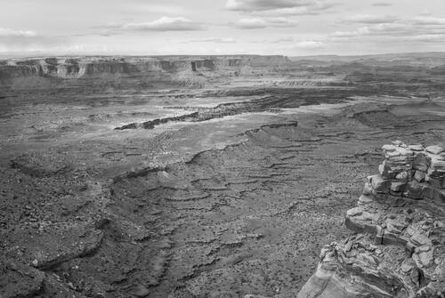
After resting in the hotel for a little bit and getting some ice cream from downtown, we headed into Canyonlands to spend our evening. We weren't expecting a good sunset because of the clouds and forecast, so we ventured to take a look at the White Rim Overlook which has spectacular views on the Eastern side of the Canyonlands National Park area. The White Rime Overlook provided a better-than-expected view of the White Rim that was very surreal to look at. On our way driving back into town for some dinner we saw the sun peek through the clouds as it was setting and provided some perfect light, which made us a little sad that we didn't pick a destination for an evening hike to catch golden hour, but we were exhausted and it was what it was at that point.
 7.24 mi
 3.6 hrs
 6,252 ft
 860 ft
Foggy Morning
We got to the trailhead and it was snowing pretty hard. Since we had plenty of time before sunrise (which never happened because of the clouds), we sat in the car and drank our coffee until the snow let up a little.
Tunnel Arch
It was a short hike to Tunnel arch from the trailhead. It wasn't much to look at so we snapped a few photos and then continued on.
Pine Tree Arch
Pine Tree Arch wasn't all that impressive, Like many arches, unless there's something in the background that you can shoot through them, the photos turn out pretty flat and boring.
Blurred
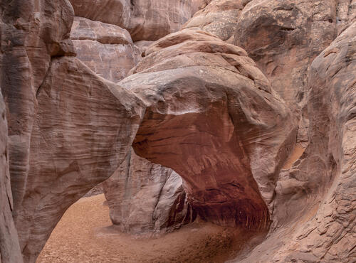
Because the sky was pretty flat and gray, it was hard to take unique photos of Skyline Arch, so both Katie and I tried to take some photos with stuff in the foreground. I love how the depth of field makes this arch look nearly broken in the middle. In reality, there's a pretty thick section that makes up the bridge to this arch.

Dry Desert
The snow helped moisten up the ground a little bit, but the photos all still looked dry. This photo was taken on the way back from Skyline Arch.
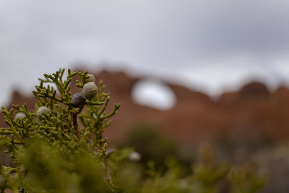
Light Snow
There was a dusting of snow on everything in the mid-morning from the morning snow.
Sandstone Arch
Sandstone Arch must get it's name from hiking through sand to get there. It's towards the ground and between two fins which makes it hard to photograph, but I feel like I got a few good photos.
Backside of Sandstone Arch
I liked Sandstone Arch because you could walk behind the arch and get up a little higher. It didn't make the composition of the photos too much better, but did give a different perspective from the backside.
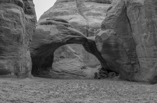
Through Broken Arch
We got to Broken Arch and took some photos, then went to the backside (where this photo was taken) which provided much better views through the arch of the valley that we hiked through to get there. It was still snowing pretty good, which was showing up in my photos everywhere.
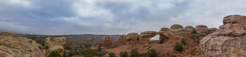
Broken Arch From Up High
I climbed up high to get a good panoramic view of the Broken Arch area.
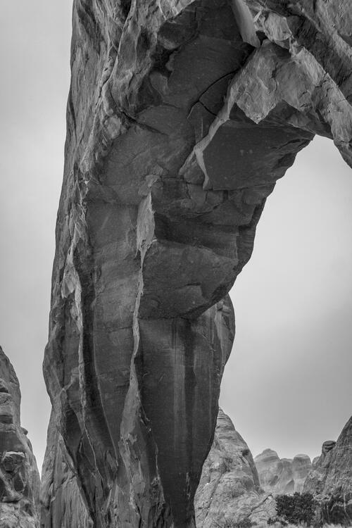
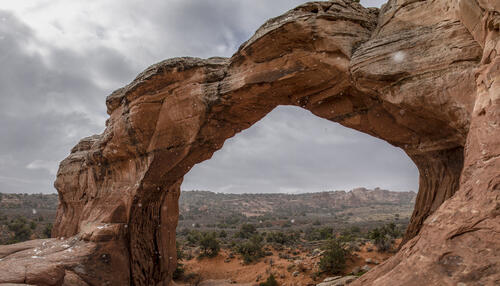
Turret Arch
We went back to the Windows section to get a better photo of Turret Arch since the first time we came to this area the sun was directly behind it.
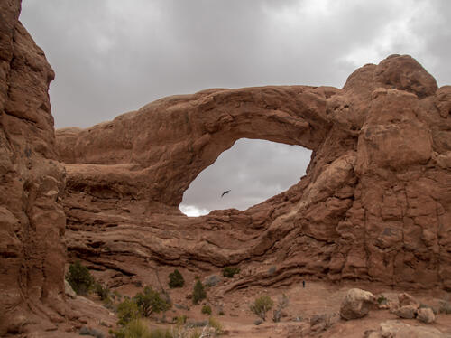
Flying Through the Window
I was able to capture a crow flying through the South Window.
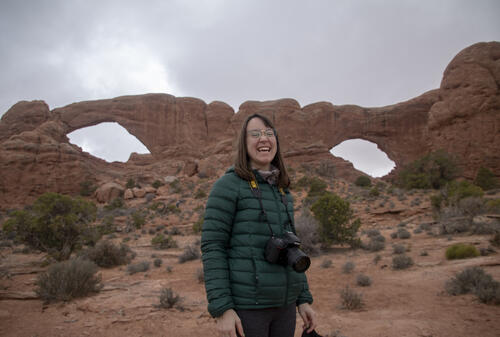
Laughing Katie
I was able to capture Katie laughing in front of both the North and South Windows by telling her that she needed to turn sideways because the gloves in her pocket was making her look fat.
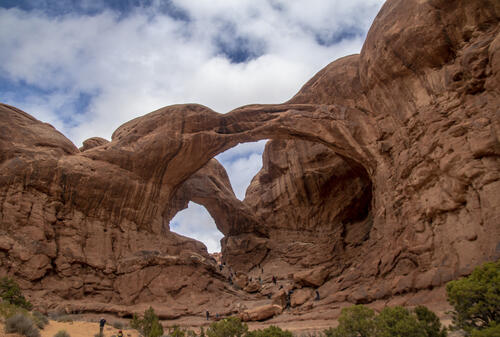
Double Arch
Double Arch is an absolutely stunning arch, but because of the massive amounts of people, it's hard to photograph it. I love how the arches are formed at different angles and that you can look through them both.
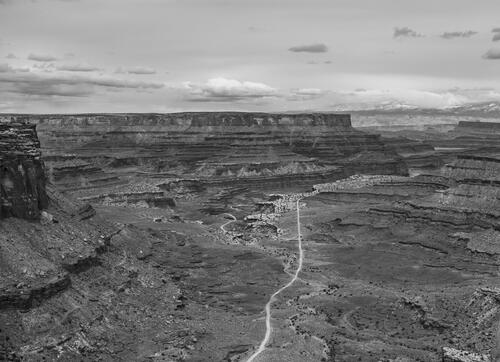
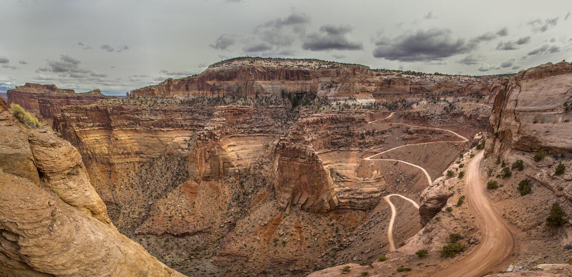
Shafer Trail Through the Canyon
The Shafer Trail ends where there's a fork in this photo. To the left is out to Potash Road, to the right is the White Rim Trail which is about 100 miles long and requires a permit. Someday we'll come back and get a permit and do some camping and do the White Rim Trail.
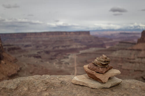
At the Edge
There were cairns marking the trails everywhere, including right off the edge of a cliff. I don't think this one was marking anything in particular, but it made for a great perspective.
Into the Canyon
We got started on our last hike of the day to go to the White Rim Overlook. Pretty early on in the hike we knew that there would be great views just based on how close you could get to the edge and look down.
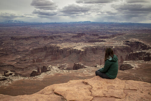
At the Edge of the Canyon
It looks like Katie's in much more danger than she actually is, there's a good ledge underneath her, but I love how the perspective looks in this photo. Not too much further from where she was sitting there was a 1,000 foot drop off, in which I was throwing rocks over the edge to get a judge of how far the bottom was. After throwing a rock, there would be a delay of about 20 seconds before you would hear a thud way down at the bottom of the Canyon.