Trap Park
It's been a few weeks since we have gotten to go out and enjoy nature. It's that awkward time of year when it's cold and snowy, but not so snowy that you know for certain if you need snowshoes yet. The day started by driving up the Poudre Canyon and turning before Cameron's Pass onto Long Draw Road. Long Draw Road is seasonally closed during the winter months, so we weren't even sure if it was open. We found out from a sign posted on the gate that it would be closed on December 1st, which meant this was our last opportunity to do this hike for the year. Long Draw Road was a snow-covered dirt road that was a little sketchy, but we only needed to drive 3 miles on it to get to the trailhead.
We started hiking around 11 am with the temperature just below freezing, but with sunny blue skies and practically no wind, the low temperatures weren't a problem at all. It was great. However, by the end of the hike, the temperature was cut in half with the wind blowing and the sun below the nearby peaks. The last couple miles of the hike were quite chilly. But we had our layers so we were uncomfortable but OK with that issue. The main problem we encountered was due to us not bringing our snowshoes since the snow on the ground at the parking lot was only a few inches. For the first mile of the hike, we were correct in our assumption that we didn't need snowshoes, but once we made it to the Northernmost tip of Trap Park there were deeper snowdrifts where snowshoes would have been beneficial. But we were too far from the car at that point so we continued hiking through the fluffy snow that was incredibly hard to hike through. Even though the hike is barely considered moderate for us based on the statistics, the extra effort that each step took trekking through the snow made this hike killer. The best approximation I can make is that each step on this hike took the effort of two steps on a summer hike just based on the resistance of the snow and having to lift our feet higher. So this 6.6 miles and sub-1,000ft elevation gain hike had us feeling similar to a hike that is 10+ miles and 2,000ft elevation gain.
The end of the hike was pretty disappointing because there were no good views at the end of Trap Park. Trap Park itself is a 2-mile long meadow between two mountains that are closed off on the South end where the end of the hike was. Usually when mountains create a bowl it makes for great photos, but the lack of a lake to keep trees out of the immediate foreground meant that the end view wasn't good at all. The best views were between miles 1 and 3 while walking along the Western side of Trap Park. But regardless of the end view, the Trap Park area is gorgeous. I bet in the summer time the area is filled with moose (and other wildlife), wildflowers, and gorgeous sunrises and sunsets. Since it was winter, we got none of these things, except for almost getting a sunset. This would be a fantastic place to do a short backpacking trip.
This hike featured amazing views of Thunder Mountain and Flattop Mountain. Not the same Flattop that we hiked earlier in November, but a different one with a similarly flat top, hence the name... We also got an amazing view of Cameron's Peak and Clark Peak with a few of the Rawaha Mountains in the distance. The mountains looked incredibly stunning with fresh snow on them especially when the sun was getting low on the horizon making them glow. Despite this hike having its technical challenges and terrible views at the end of the trail, this was the best view on the hike. We were treated to an even more spectacular view of those same mountains as we were driving back down Long Draw Road after the hike.
Other than the great views during the hike, one fantastic thing about this hike was that we didn't see a single other person on the trail. This has only happened one other time for us, when we did Trianlge Mountain in 2022. This designation is special to us since one of the reasons that we go out into nature is to get away from other people. I'm surprised with how many remote hikes we've done that we haven't had more people-less hikes, but we've come close a few times this year. Hopefully next year we can get at least another secluded hike all to ourselves.
As of this hike, we've hiked 50 trails this year. Two more and we will be at an average of one hike per week. This is pretty impressive since we often can't get out every weekend. Other than living our typical busy lives that tie us up on some weekends, the weather is also often uncooperative for us in the middle of winter. Getting to 52 hikes in one year is an accomplishment that I've wanted to do for a while, but I have never wanted to push myself for it because I don't particularly appreciate making goals that you can easily get behind which can often make one stop caring about completing the goal altogether. But it would be cool to squeeze in two more hikes this year (which I think we should be able to manage).
 6.51 mi
 4.9 hrs
 10,586 ft
 902 ft
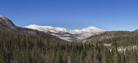
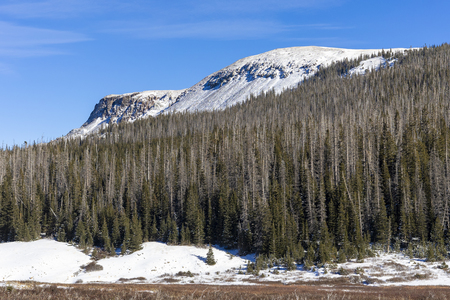
Towards the Rawahs
Shortly into the hike we got a fantastic view of Cameron's Peak (right), Clark Peak (left) and a few of the Rawah's in the distance.
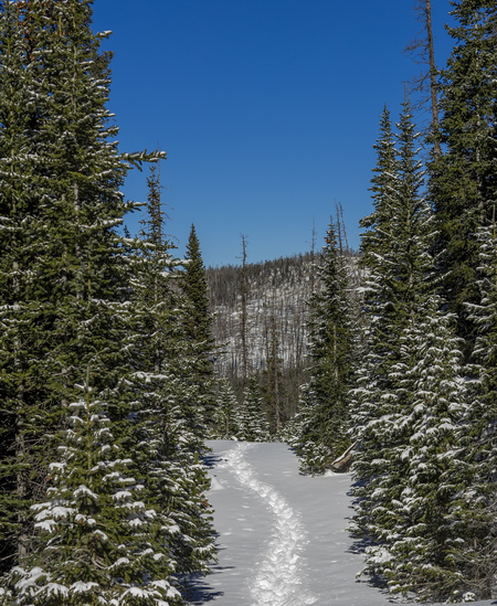
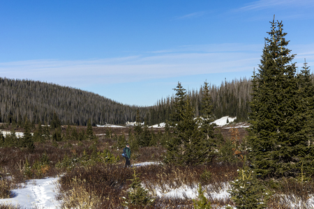
The Small Trail
There was a trail from a person a few days ago for the first mile of the hike, but otherwise we were breaking trail being the only ones out here.
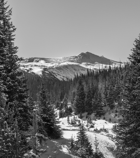
Thunder Mountain
We got great views of Thunder Mountain after about a mile into the hike when we made it to the Northernmost tip of Trap Park
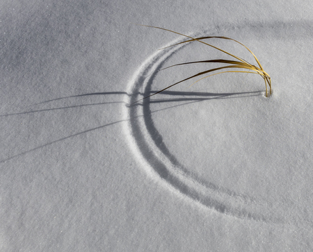
Simple Arcs
The grass was dancing with the wind creating arcs on the soft snow. The simplicity of what's happening here was very intriguing to me.
Flattop Mountain
We came across another Flattop Mountain on this hike.
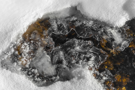
Frozen Creek
Trap Creek was barely frozen over. We occasionally heard the ice cracking under our feet not knowing we were even on a river or knowing how deep it was. But when we came to a section that wasn't completely frozen we realized that this creek had barely any water in it.
Near the End of the Trail
We made it to the disappointing end of the trail which had no views. Katie started heading back while I took a few shots knowing that I would catch up to her.
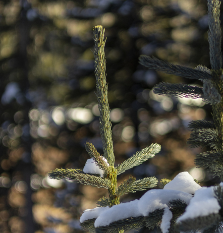
Bokeh In the Trees
I was able to identify this shot as one that would have good bokeh before putting my eye up to the camera. The slivers of sight through the trees int he distances is what caught my attention.
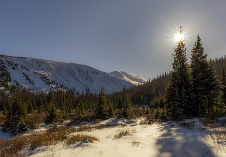
Low Sun
The sun was getting low in the sky even though it was only in the 3-o'clock hour. It provided very nice soft lighting and allowed me to catch some good sun flares - which is something that's harder to do when the sun is higher in the sky.
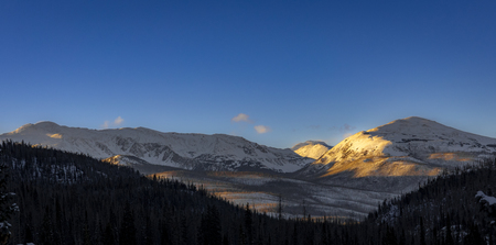
Setting Sun
The sun was starting to set by the time we made it back to the area where we could see Cameron Peak (right), Clark Peak (left) and the Rawah's (in the distance). The lighting was stunning and made up for some of the disappointing views at the end of the trail.


